- Lake Virisen - | Back to Start Page | Fishing waters Lappland |
Lake in southwest Lappland. located approx. 50 km south of Tärnaby. 605 above sea level. Approx. 20 km long. Area: 2470 km². Fishing is allowed all year round. The lake have a nice population of char and trout. Fishing from boat is the common way to fish in this lake. But both ends (at the in- and outflow) of the lake can offer great fishing for char at late evenings. Just wade out into the water and wait for the char to get in reach for a cast.
Boats can be rented by: The biggest trout caught on rod weighed 6.1 kg, the fish was caught on a small gold rapala. Biggest trout caught by net weighed 8 kg. Ice fishing record, a char weighing 1,4 kg. At winter time the lake offers nice icefishing. The lake is controlled by the state. You have to buy the "Statens Allmänna fjällfiskekort" fishing permit. For prices and more info on this permit read here. You can buy fishing permits at http://www.natureit.se/sv a mountain farm located just next to the lake on the north side. You can also buy permits at tourist offices, tackle shops in nearby located villages. Tarns in Bränkonjuone, an area of small tarns just south of lake Virisen, total water area: 60 km², Fishing for trout and char. You can buy fishing permits at http://www.natureit.se/sv, a mountain farm located just next to the lake on the north side. You can also buy permits at tourist offices, tackle shops in nearby located villages. Granån, small river at the east end of the lake Virisen (map). Limited access. The stretch is 2 km long, stretches from lake Virisen downstream to lake Bleriken. Only flyfishing is allowed here. Bag limit and minimum length: 300 mm.
From south
From north Recommended map of the area:
Lake Virisen marked on map of Sweden Fishing tips (in Swedish) Articles, books, about lake Virisen Notices on lake Virisen (in Swedish)
Air service:
Fishing guides, fishing charter Virisen Lappland, Mountain Farm
Accommodation/Logding Virisen Lappland, Mountain Farm, Tomas and Gunilla in Virisen. Modern logcabins for rent, guiding service. Restaurant.
Tackle shops Virisen Lappland, Mountain Farm (small assortment of sportfishing equipment) List of tackleshops i Lappland
Tourist information
External links
Fishing articles, books about Virisen ----
You are welcome and send us fishing info or fishing reports regarding Virisen, mail us
© Cinclus C 2017
|
|
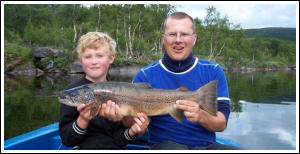 Trout from lake Virisen
|